European Atlantic Geoparks Route
  • Home
  • The Route
  • Discover
    • Geoparks
    • Interests
      • Geosites
      • Landscapes
      • Experiences
      • Museums and Interpretative Centre
    • Uses And Customs
      • Traditions
      • Gastronomy
    • Services
      • Accomodation
      • Restaurants
    • Thematics
      • Family Fun
      • Kids Fun
      • Adventure
      • Education
    • Plan Your Route
    • Interactive Map
  • Events
  • News
  • Project
    • Atlantic Geoparks Project
    • Partners
    • Work Packages
      • WP1. Project Management
      • WP2. Project Communication
      • WP3. Capitalization
      • WP4. Geo-site Management
      • WP5. Transnational Marketing: The European Atlantic Geotourism Route
      • WP6. ICT Tools for Discovery, Understanding and Enjoyment
      • WP7. Training and Capacity Building
    • Meeting & Study Visits
    • Geotourism Monitoring System
  • Contacts
    • Contact Us
    • Directory
0
No Result
View All Result
en
en fr de it pt es
European Atlantic Geoparks Route
0
en
en fr de it pt es
EAGR map

EAGR map

Share:

Atlantic Geoparks Project launches website to promote geotourism in the Atlantic Area

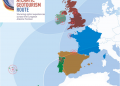
The Atlantic Geoparks project has launched a new website to promote Geotourism in the European Atlantic Area. The website features 11 geotourism destinations which span the Atlantic frontier from Ireland and the UK, to France, Portugal, Spain and over to the Atlantic islands of Lanzarote and the Azores.

The geotourismroute.eu website promotes transnational geotourism along the western edge of Europe and will provide inspiration to those looking for exceptional travel experiences in remarkable landscapes. The site puts North Western Europe at the forefront of the growing international geotourism market.

Geotourism encourages slow travel and exploration of the landscape. It promotes the outdoors and the many ways you can immerse yourself in the culture of each of the featured regions. Each destination provides a window into the development of our Earth and tells a distinctive, dramatic and enthralling chapter of the story of life on the Atlantic frontier. Walking trails, cycling routes and water-based activities are just some of the inspirational activities featured on the site.

‘The website guides you through diverse territories, countries, habitats, languages and cultures’ said Artur Sá, University of Trás-os-Montes and Alto Douro, Atlantic Geoparks project leader. ‘Each of the stunning destinations are linked together by one powerful mission – to provide the highest quality visitor experiences while helping to power their local economies’ he continued ‘And by promoting them through an interactive website we hope to inspire future travellers’

The new website is just one element of the suite of products that is being developed by the EU funded Atlantic Geoparks project which involves international partners working collaboratively to support the development of sustainable geotourism in the European Atlantic Area.

With the website launching just as Europe is emerging from a long period of lockdown following the COVID-19 pandemic it is hoped that it can play a role in getting the economies of these regions which are highly dependent on tourism back on track.

‘Tourism destination have suffered greatly in recent months’ said Antonio Duarte, Arouca Geopark, website development partner ‘And we hope by shining a light on the truly inspirational landscapes and the outdoor experiences that are provided within them through this new website that we can encourage visitors both in the regions and internationally to visit when the time is right’.

About the Atlantic Geoparks project

The Atlantic Geoparks project is co-funded by the EU Interreg Atlantic Area programme. The project aims to forge new tourism links along a defined Atlantic route through highlighting the common interests and heritage of the destinations along the route. For more information see: https://geotourismroute.eu/atlantic-geoparks-project/

Project partners:

  • University of Trás-os-Montes and Alto Douro (Portugal)
  • Arouca Geopark (Portugal)
  • Azores Geopark (Portugal)
  • Forest Fawr Geopark (UK)
  • Marble Arch Geopark (Northern Ireland / Ireland)
  • Basque Coast Geopark (Spain)
  • Lanzarote Geopark (Spain)
  • Sustainable Municipalities Community of Cantabria Aspiring Geopark (Spain)
  • PNR Armorique Aspiring Geopark (France)
  • North Pennines AONB Geopark (UK)
  • Burren and Cliffs of Moher Geopark (Ireland)
  • Copper Coast Geopark (Ireland)

About the INTERREG Atlantic Area Programme

INTERREG Atlantic Area is an European funding programme that promotes transnational cooperation among 36 Atlantic regions of five European countries. With a total budget of € 185M, being €140M of European Regional Development Fund (ERDF), this programme co-finances cooperation projects in the fields of Innovation & Competitiveness, Resource Efficiency, Territorial Risks Management, Biodiversity and Natural & Cultural Assets.

The Atlantic Area covers the western part of Europe bordering the Atlantic Ocean. It comprises regions from the western part of the United Kingdom, Ireland and Portugal as well as the northern and south westernmost part of Spain and western France.

The Programme main objective is to strengthen the integrated territorial development and cooperation in the Atlantic area.

Previous Post

Paiva Walkways wins a "World Travel Awards"

Next Post

Webinar on “Transnational Cooperation of the Atlantic Geoparks for Sustainable Development”

Latest News

Web Conference “Atlantic Geoparks – Geotourism for Sustainability”

Web Conference “Atlantic Geoparks – Geotourism for Sustainability”

27th October 2020
Webinar

Webinar on “Transnational Cooperation of the Atlantic Geoparks for Sustainable Development”

14th July 2020
EAGR map

Atlantic Geoparks Project launches website to promote geotourism in the Atlantic Area

1st July 2020
Paiva Walkways wins a “World Travel Awards”

Paiva Walkways wins a “World Travel Awards”

21st June 2018

Upcoming Events

Current Month

march, 2023

No Events

Next Post
Webinar

Webinar on “Transnational Cooperation of the Atlantic Geoparks for Sustainable Development”

Interreg Logo

This project is co-financed by the Interreg Atlantic Area Programme through the European Regional Development Fund.

About Us

A new, awe-inspiring trail of magnificent destinations awaits you right along the epic expanse of the Atlantic frontier. It winds an intriguing transnational path from Ireland and the UK, to France, Portugal and Spain over to the Atlantic Islands of Lanzarote and down to the Azores.

Main Menu

  • Home
  • The Route
  • Discover
  • Events
  • News
  • Projects
  • Documents
  • FAQ’s
  • Contacts
  • Privacy Policy

Useful Links

  • Arouca Geopark
  • Azores Geopark
  • North Pennines Geopark
  • Marble Arch Caves Geopark
  • Mancomunidad de Municipios Sostenibles
  • Lanzarote and Chinijo Islands Geopark
  • Fforest Fawr Geopark
  • Copper Coast Geopark
  • Burren & Cliffs of Moher Geopark
  • Basque Coast Geopark
  • Armorique Geopark

Instagram

The Atlantic Geoparks project which created the At The Atlantic Geoparks project which created the Atlantic Geotourism Route is hosting its final conference. The virtual event takes place on 5th November with a theme of “Atlantic Geoparks – Geotourism for Sustainability” and aims to present not only the results of this project, but also to discuss the growing importance of geotourism in the development of territories.

To participate in this online conference, through the Zoom platform, go to https://bit.ly/37Kd2wb

Project partners and contributors include:
Marble Arch Caves Global Geopark
Copper Coast Geopark 
North Pennines AONB Partnership 
Fforest Fawr Unesco Global Geopark 
Azores Geopark 
Arouca Geopark 
Geopark Armorique 
The Burren and Cliffs of Moher Unesco Global Geopark Geoparque Valles de Cantabria 
Geoparque Mundial Unesco de Lanzarote y Archipiélago Chinijo 
Geoparkea - Basque Coast Unesco Global Geopark 

Interreg Atlantic Area European Geoparks Network Global Geoparks Network
GEOSITE OF THE WEEK: Craig Cerrig-Gleisiad a Fan F GEOSITE OF THE WEEK: Craig Cerrig-Gleisiad a Fan Frynych Nationa Nature Reserve, Fforest Fawr Unesco Global Geopark

Located close to the the Brecon Beacon’s National Park Visitor Centre in Libanus you will find this shady, atmospheric amphitheatre created by the soaring, craggy cliffs of Craig Cerrig Gleisiad.

Try the waymarked walks to get a flavour of the reserve or, for map-readers wanting a longer walk, footpaths lead upwards to the lofty, exposed moorlands of Fan Frynych and across to the spectacular cliffs at Craig Cwm Du.

#Geotourism #atlanitcfrontier #EarthHeritage #Geopark 

https://geotourismroute.eu/interests/craig-cerrig-gleisiad-a-fan-frynych-nationa-nature-reserve/
GEOSITE OF THE WEEK; The Cliffs of Moher, The Burr GEOSITE OF THE WEEK; The Cliffs of Moher, The Burren and Cliffs of Moher Unesco Global Geopark.

Standing 214m at their highest point, the Cliffs of Moher stretch along the Atlantic coast of County Clare, Ireland. They are one of Ireland’s most visited natural attractions. The Cliffs of Moher Visitor Experience Centre is open all year round. Highlights include over 800m of cliff edge paths and viewing areas, the gothic style 19th century O’Briens Tower near the highest point of the cliffs and the eco-friendly underground visitor centre building containing visitor services and facilities, gift shop, restaurant & coffee shop and the award winning Atlantic Edge Exhibition.

#geotourism #AtlanticArea #AtlanticFrontier #EarthHeritage #Geopark #UNESCO
GEOSITE OF THE WEEK: Cavan Burren Park, Marble Arc GEOSITE OF THE WEEK: Cavan Burren Park, Marble Arch Caves Global Geopark

Cavan Burren Park is a mythical, spiritual landscape of monuments, megalithic tombs, hut sites and pre-bog walls all of which survive from pre-historic times and are located within metres of each other. The Park offers stunning views of Cuilcagh Mountain, West Cavan and the greater Marble Arch Caves UNESCO Global Geopark. A visitor centre interpreting the archaeological, geological and cultural history of Cavan Burren Park opened in May 2014. Enjoy the five walking trails including one multi-access trail as well as picnic facilities, coach parking, toilet facilities and interpretation of archaeological and geological attractions. The site is opened all year round and admission is free.

#Geotourism #AtlanticArea #AtlanticFrontier #EarthHeritage #Geopark
Walking is a wonderful way to discover the landsca Walking is a wonderful way to discover the landscape and the Beacons Way will take you through the stunning surrounds of Fforest Fawr Unesco Global Geopark

The Beacons Way is an iconic walk which runs the length of the Brecon Beacons National Park. It is a challenging route, but well within the reaches of a fit and competent hill walker. Demanding uphill climbs and undulating ridges give spectacular views of the National Park, its varied landscapes and its wildlife.

#Geotourism #EarthHeritage #Geopark #Walking #AtlanticFrontier
https://geotourismroute.eu/interests/beacons-way/
GEOSITE OF THE WEEK: Capelinhos Volcano and Costad GEOSITE OF THE WEEK: Capelinhos Volcano and Costado da Nau Volcano, Azores Geopark

Capelinhos volcano is the most recent (1957/58) and western monogenetic volcano of the Capelo peninsula. The 13 months basaltic eruption started as submarine and evolved to a terrestrial one, an eruptive sequence also well exposed on the nearby deeply eroded fossil sea cliff of “Costado da Nau”.The Capelinhos eruption had a big relevance for volcanology science and caused significant socio-economic impacts in the community of the island.

The Capelinhos Volcano Interpretation Centre (CIVC) has an informative, educational and scientific mission, having for that purpose, a set of exhibitions with a special emphasis on Capelinhos Volcano eruption and the formation of the archipelago, but also related to the various kinds of volcanic activity in the world and the history of Azorean lighthouses.

It was appointed by the European Museum Forum, for best European museum in 2012.

#Geotourism #AtlanticFrontier #EarthHeritage #Geopark
GEOSITE OF THE WEEK: Caldeira e Furna do Enxofre, GEOSITE OF THE WEEK: Caldeira e Furna do Enxofre, Azores Geopark

The Furna do Enxofre, situated in the south-eastern part of the Caldeira da Ilha Graciosa, is an impressive lava cave, whose main feature is its perfect dome-shaped roof. The inside of the cave is reached via a tower roughly 37 metres high and containing a spiral staircase with 183 steps.

It is considered unique in the international panorama of volcanism and speleology. The cave's origin is associated with an important period of effusive intracrater activity of the Hawaiian type.

Inside, besides a lake of cold water, there is an important degasification field consisting of a mud pot and diffuse gaseous emanations of carbon dioxide, which are released imperceptibly in various areas of the cave floor.

#Geotourism #AtlanticFrontier #EarthHeritage #Geopark

https://www.visitportugal.com/en/NR/exeres/CA19BE18-291C-4C1D-AAC6-3B99537A756D
GEOSITE OF THE WEEK: Birthing Stones, Arouca Geop GEOSITE OF THE WEEK: Birthing Stones, Arouca Geopark

The ‘stones that give birth’ when translated from Portuguese. Geologically designated as “nodular granite of Castanheira”. They are one of the iconic aspects of the Arouca Geopark. Occurring within a section of granite, lumps of dark minerals have formed and over many years, because of erosion and changes in temperature, it appears like the nodules grow out of the stone and then pop off. These nodules present dimensions that vary between 1 to 12 centimeters diameter.

This geosite is located on one of the Driving route through Arouca Geopark that takes in the Freita Mountain’s plateau and along the 'Enchanted Mountain'

#Geotourism #AtlanticFrontier #EarthHeritage #Geopark

https://geotourismroute.eu/interests/birthing-stones/
Geosite of the week: Ason Collados Set, Mancomunid Geosite of the week: Ason Collados Set, Mancomunidad de Municipios Sostenibles Cantabria

The long valley that extends between Bustalveinte and the hills of the Ason has is a stunning geomorphologic vision, combining glacial forms, karstic and unique hillside vistas. 

Situated in the valleys of Cantabria it make for a spectacular driving route 

#Geotourism #AtlanticFrontier #EarthHeritage #Geopark

© 2020 European Atlantic Geoparks Route All rights reserved

No Result
View All Result
  • Home
  • The Route
  • Discover
    • Geoparks
    • Interests
      • Geosites
      • Landscapes
      • Experiences
      • Museums and Interpretative Centre
    • Uses And Customs
      • Traditions
      • Gastronomy
    • Services
      • Accomodation
      • Restaurants
    • Thematics
      • Family Fun
      • Kids Fun
      • Adventure
      • Education
    • Plan Your Route
    • Interactive Map
  • Events
  • News
  • Project
    • Atlantic Geoparks Project
    • Partners
    • Work Packages
      • WP1. Project Management
      • WP2. Project Communication
      • WP3. Capitalization
      • WP4. Geo-site Management
      • WP5. Transnational Marketing: The European Atlantic Geotourism Route
      • WP6. ICT Tools for Discovery, Understanding and Enjoyment
      • WP7. Training and Capacity Building
    • Meeting & Study Visits
    • Geotourism Monitoring System
  • Contacts
    • Contact Us
    • Directory

© 2020 European Atlantic Geoparks Route All rights reserved

Login to your account below

Forgotten Password?

Fill the forms bellow to register

All fields are required. Log In

Retrieve your password

Please enter your username or email address to reset your password.

Log In
X